Traffic information on the map
If you subscribe to the SIRIUS XM Satellite Radio Traffic Message Service, traffic information can be displayed on the map. You can select three categories for the display.
 To switch the displays on/off: press
  the COMAND controller to show the menu.
Select Navi in the main function bar by
sliding  and turning
  the COMAND
controller and press to confirm.
the COMAND
controller and press to confirm.
Select Traffic Information On Map and
press to confirm.
Select a category and press to
confirm.
Depending on the previous state, switch
the option on  or off
 .
.
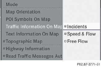
• Traffic incidents
Road sections are illustrated with a yellow line and arrows.
Warning messages or traffic incidents are represented on the map by appropriate symbols and/or yellow/red arrows.
Explanation of symbols.
• Speed & Flow
Road sections are represented by yellow or red car icons.
Green arrows: free-flowing traffic
Yellow car icons: congested traffic, average speed 25 - 45 mph
Red car icons: traffic jam, average speed 5 – 20 mph
• Free Flow
Road sections are illustrated with a green line and arrows.
See also:
Problems with PARKTRONIC
Problem
Possible causes/consequences and
Solutions
Only the red segments in the PARKTRONIC warning displays
are lit.
You also hear a warning tone for approximately two ...
Function restrictions
You will not be able to use the telephone, will
no longer be able to use the telephone, or you
may have to wait before using it, in the
following situations:
• when the mobile phone is switch ...
Power washers
WARNING
Do not use power washers with circular-jet nozzles (dirt grinders) to clean your
vehicle, in particular the tires. You could otherwise damage the tires and cause
an accident.
Alw ...