Traffic information on the map
If you subscribe to the SIRIUS XM Satellite Radio Traffic Message Service, traffic information can be displayed on the map. You can select three categories for the display.
 To switch the displays on/off: press
  the COMAND controller to show the menu.
Select Navi in the main function bar by
sliding  and turning
  the COMAND
controller and press to confirm.
the COMAND
controller and press to confirm.
Select Traffic Information On Map and
press to confirm.
Select a category and press to
confirm.
Depending on the previous state, switch
the option on  or off
 .
.
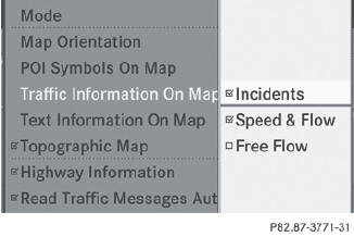
• Traffic incidents
Road sections are illustrated with a yellow line and arrows.
Warning messages or traffic incidents are represented on the map by appropriate symbols and/or yellow/red arrows.
Explanation of symbols.
• Speed & Flow
Road sections are represented by yellow or red car icons.
Green arrows: free-flowing traffic
Yellow car icons: congested traffic, average speed 25 - 45 mph
Red car icons: traffic jam, average speed 5 – 20 mph
• Free Flow
Road sections are illustrated with a green line and arrows.
See also:
Preparing the cargo net
The cargo net can be used in two different positions (behind the B-pillar or
the C-pillar).
The brackets behind B-pillar : are required for the cargo compartment enlargement
(). The corresp ...
Number of seats
The specifications shown on the Tire and
Loading Information placard in the
illustration are examples. The number of
seats is vehicle-specific and can differ from
the details shown. The numbe ...
Position of the steering wheel for driving
The steering wheel is moved to the last selected position when:
• the driver's door is closed.
• you insert the SmartKey into the ignition lock.
or
• you press the Start/Stop button once on vehicl ...