Traffic information on the map
If you subscribe to the SIRIUS XM Satellite Radio Traffic Message Service, traffic information can be displayed on the map. You can select three categories for the display.
 To switch the displays on/off: press
  the COMAND controller to show the menu.
Select Navi in the main function bar by
sliding  and turning
  the COMAND
controller and press to confirm.
the COMAND
controller and press to confirm.
Select Traffic Information On Map and
press to confirm.
Select a category and press to
confirm.
Depending on the previous state, switch
the option on  or off
 .
.
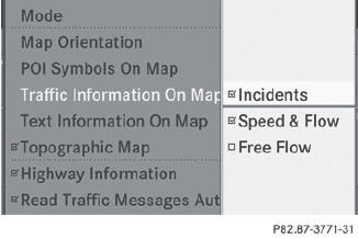
• Traffic incidents
Road sections are illustrated with a yellow line and arrows.
Warning messages or traffic incidents are represented on the map by appropriate symbols and/or yellow/red arrows.
Explanation of symbols.
• Speed & Flow
Road sections are represented by yellow or red car icons.
Green arrows: free-flowing traffic
Yellow car icons: congested traffic, average speed 25 - 45 mph
Red car icons: traffic jam, average speed 5 – 20 mph
• Free Flow
Road sections are illustrated with a green line and arrows.
See also:
Breaking-in notes
The first 1000 miles (1500 km)
The more you look after the engine when it is
new, the more satisfied you will be with its
performance in the future.
• Drive at varying vehicle speeds and
engine
...
Making adjustments in 5 mph (Canada:
10 km/h) increments
Briefly press the cruise control lever
beyond the pressure point, up 1 for a
higher speed or down 2 for a lower speed.
The last speed stored is increased or
reduced. ...
Ashtray in the rear-compartment centerconsole
Close the ashtray when it is not in use and
before you fold the rear seats forward. You
can otherwise damage the ashtray.
► To open: briefly press marking 2.
Ashtray 2 opens.
► ...