Map information in the display
Showing text information
During route guidance, you can have map information displayed at the bottom edge of the display.
 To show the menu: press
  the COMAND
controller.
the COMAND
controller.
Select Navi in the main function bar by
sliding  and turning
  the COMAND
controller and press to confirm.
the COMAND
controller and press to confirm.
The main area is active.
Select Navi again and press
to confirm.
The navigation menu opens.
Select Text Information on Map and
press to confirm.
A  dot indicates the current
setting.
dot indicates the current
setting.
Select Arrival Time/Distance,
Current Street, Geo-Coordinates or
None and press to confirm.
To exit the menu: slide  the COMAND
controller.
the COMAND
controller.
Arrival time/distance to the destination
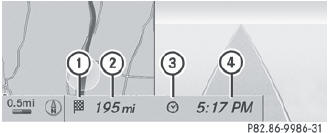
Arrival time/distance display switched on
1 Icon for destination
2 Distance to the destination
3 Icon for estimated time of arrival
4 Estimated time of arrival
You can only see this display during route guidance. While scrolling the map, you will see additional data, e.g. road names, depending on the crosshair position, if the digital map supports this data.
Road display
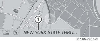
Road display active
1 Road names or numbers, e.g. for highways
Geo-coordinate display

Geo-coordinate display active
1 Current height above average sea level,
rounded
2 Current vehicle position: latitude
coordinates
3 Current vehicle position: longitude
coordinates
4 Number of GPS satellites currently being
used
There must be sufficient GPS reception for all displays to be shown. If this is not the case, the display will be grayed out. Height display 1 may vary from the actual value, because the navigation system uses the GPS signals for the calculation.
While scrolling the map, you will see the geo-coordinates of the crosshair position. Height display 1 and number of satellites used 4 are not displayed.
"None" menu option
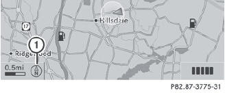
Display switched off
1 Current map orientation
 During the "Move map" function you can
see additional information depending on
the position of the crosshair, such as a road
name, if the digital map supports this data.
During the "Move map" function you can
see additional information depending on
the position of the crosshair, such as a road
name, if the digital map supports this data.
See also:
Setting the glove box air vent
When automatic climate control is activated, the glove box can be ventilated,
for instance to cool its contents. The level of airflow depends on the airflow and
air distribution settings.
Clos ...
Displays and controls
1 Speedometer with segments
2 Multifunction display
3 Tachometer
4 Coolant temperature
5 Fuel gauge
6 Instrument cluster lighting brightness control: turn clockwise or
counterclockwise ...
Storing the ball coupling
WARNING
Do not carry the ball coupling in the vehicle interior if it is not secured.
Otherwise, you and others could be injured by the ball coupling being thrown
around if you:
brake shar ...