Map display
Setting the map orientation
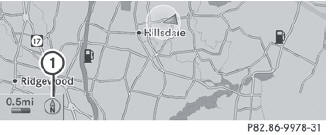
Map orientation
1 Current map orientation
The following display modes are possible:
•  North orientation (the map view
is
displayed so that north is always up).
North orientation (the map view
is
displayed so that north is always up).
•  Orientation in direction of
travel (the
map is displayed so that the direction of
travel is always up; the orange point of the
icon points north).
Orientation in direction of
travel (the
map is displayed so that the direction of
travel is always up; the orange point of the
icon points north).
•  Bird's-eye view (the map is
displayed so
that the direction of travel is always up; the
map projection reproduces the curvature
of the earth and the orange point of the icon
points north).
Bird's-eye view (the map is
displayed so
that the direction of travel is always up; the
map projection reproduces the curvature
of the earth and the orange point of the icon
points north).
•  3D map (the map is displayed in
the
direction of travel with elevation and terrain
modeling. The orange point of the icon
points north).
3D map (the map is displayed in
the
direction of travel with elevation and terrain
modeling. The orange point of the icon
points north).
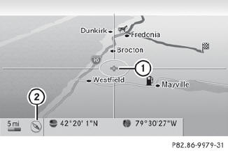
Example display: Bird's-eye view
1 Current crosshair position
2 Current map orientation
 To show the menu: press
  the COMAND
controller.
the COMAND
controller.
Select Navi in the main function bar by
sliding  and turning
  the COMAND
controller and press to confirm.
the COMAND
controller and press to confirm.
Select Map Orientation and press
to
confirm.
A  dot indicates the current
setting.
dot indicates the current
setting.
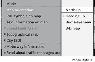
Select North Up, Heading Up, Bird'seye
View or 3-D Map by turning
the
COMAND controller and press to
confirm.
To exit the menu: slide  the COMAND
controller.
the COMAND
controller.
The map orientation changes accordingly.
Setting the point of interest icons in the map
You can set the points of interest you wish to have displayed as symbols on the map. Points of interest are, for example, gas stations, hotels, cinemas and restaurants.
The following settings are possible:
• Standard Symbols
Symbol display determined by the factory
settings.
• Personal Symbols
You can determine the symbols yourself.
• No Symbols
The map does not show any symbols.
To show the menu: press
the COMAND
controller.
Select Navi in the main function bar by
sliding and turning
the COMAND
controller and press to confirm.
Select POI Symbols on Map and press
to confirm.
Select Standard Symbols, Personal
Symbols or No Symbols.
If you select Personal Symbols, the list of points of interest appears.
To switch the icon display on/off: select
a point of interest by turning
the
COMAND controller and press to
confirm.
Depending on the previous state of the
symbols, they will either be shown  or
hidden
or
hidden  . You can switch on the
symbol
displays for more than one point of interest.
. You can switch on the
symbol
displays for more than one point of interest.
 The list shows all symbols that are
contained on the digital map across all
countries. However, not all points of
interest are available in all countries. As a
result, certain point of interest symbols
may not be displayed on the map, even if
the symbol display is switched on.
The list shows all symbols that are
contained on the digital map across all
countries. However, not all points of
interest are available in all countries. As a
result, certain point of interest symbols
may not be displayed on the map, even if
the symbol display is switched on.
To exit the menu: press the  back
button.
back
button.
See also:
Notes on using 3-zone automatic
climate control
The following contains notes and
recommendations on optimum operation of
automatic climate control.
- Activate climate control using the
and
buttons. The indicator lamps in the
and
butt ...
Adjusting the head restraints
electrically
- To adjust the head restraint height: slide
the switch for head restraint adjustment
up or down in the direction of
the arrow. ...
Driving with summer tires
At temperatures below 45 °F (+7 °C), the
elasticity of summer tires and therefore also
traction and braking capability are reduced
considerably — equip your vehicle with
M+S tires. Using summer ti ...