Real-time traffic reports on the map
COMAND can show certain traffic incidents on the map. The incidents are shown on the map at a scale from 1/16 mi to 20 mi.
 Set the map scale.
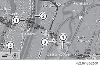
12 Icon display for the section of route affected
3 Icon for incident on the route
4 Current position and direction of travel
5 Map scale
 COMAND uses corresponding icons to
highlight the entire section of the affected
route, regardless of how long the incident
actually is. The icons are placed on the side
of the road affected by the incident.
COMAND uses corresponding icons to
highlight the entire section of the affected
route, regardless of how long the incident
actually is. The icons are placed on the side
of the road affected by the incident.
See also:
Connecting AUX equipment
AUX drive
The AUX drive jacks are located on the CD/DVD drive on the right next to the
CD/DVD
eject button.
Displaying AUX
The AUX display jacks are on the side of the
screen.
Audio and vide ...
Cockpit
...
Storing the ball coupling
WARNING
Do not carry the ball coupling in the vehicle
interior if it is not secured.
Otherwise, you and others could be injured by
the ball coupling being thrown around if you:
- brake sharply ...